Файл:Russia ethnic.JPG
Эх файл (1,017 × 1,253 пиксел, файлын хэмжээ: 501 КБ, MIME төрөл: image/jpeg)
| Тайлбар |
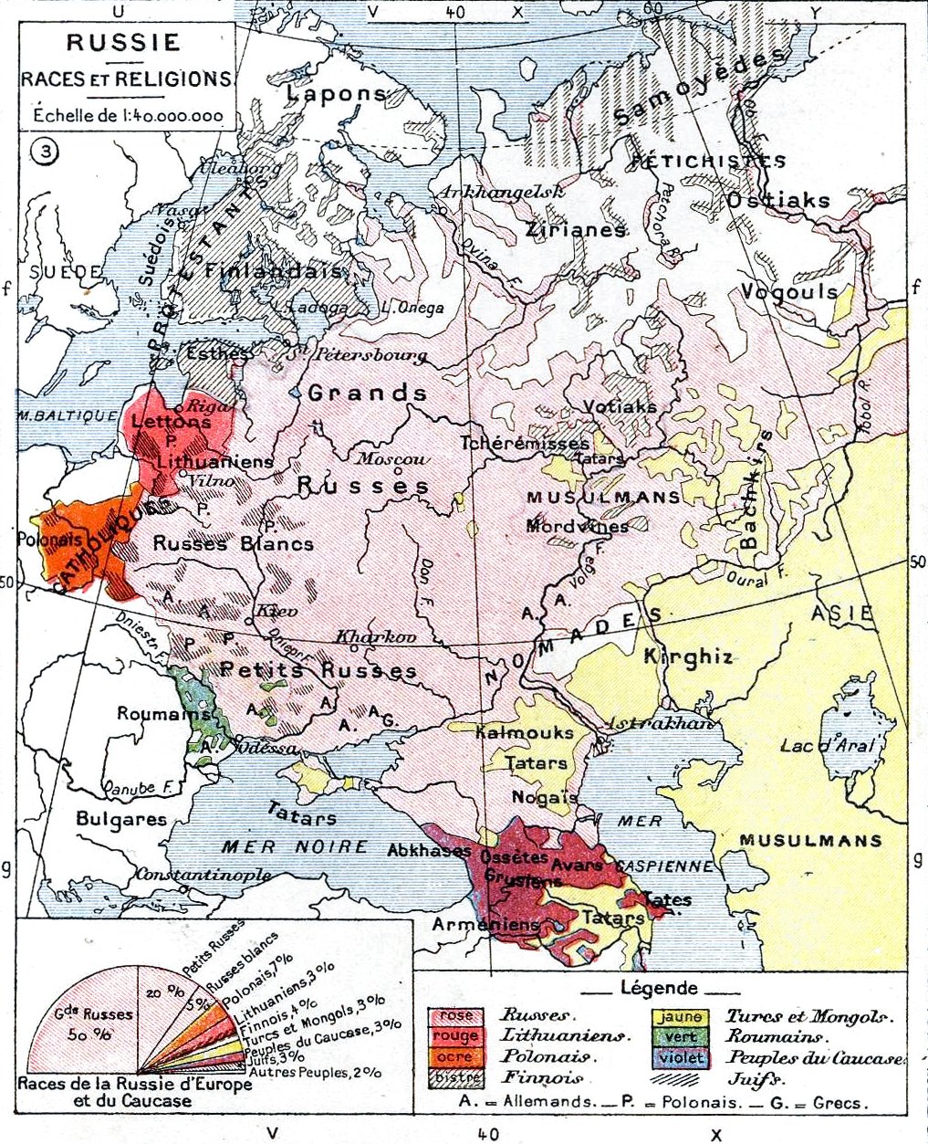
English: Ethnic map of the European part of the Russian Empire
Deutsch: Ethnische Karte des europäischen Russland vor dem Ersten Weltkrieg |
||||
| Огноо | |||||
| Эх үүсвэр | Histoire Et Géographie - Atlas Général Vidal-Lablache, Librairie Armand Colin, Paris, 1898 | ||||
| Зохиогч | own scan | ||||
| Зөвшөөрөл (Энэ файлыг дахин ашиглах) |
|
||||

|
This old map image could be re-created using vector graphics as an SVG file. This has several advantages; see Commons:Media for cleanup for more information. If an SVG form of this image is available, please upload it and afterwards replace this template with
{{vector version available|new image name}}.
It is recommended to name the SVG file “Russia ethnic.svg”—then the template Vector version available (or Vva) does not need the new image name parameter. |


Файлын түүх
Огноо/цаг дээр дарж тухайн үеийнх нь файлын байдлыг харна уу.
| Огноо/Цаг | Жижиг зураг | Хэмжээ | Хэрэглэгч | Тайлбар | |
|---|---|---|---|---|---|
| одоогийн | 20:00, 10 Тавдугаар сар 2011 | | 1,017 × 1,253 (501 КБ) | Alex:D | Revert. The original author agreed with this version, stop messing around... |
| 01:24, 5 Гуравдугаар сар 2011 |  | 1,017 × 1,253 (1.34 МБ) | Vizu | Reverted to version as of 13:39, 13 November 2009 Original colours | |
| 15:20, 15 Арваннэгдүгээр сар 2009 |  | 1,017 × 1,253 (501 КБ) | Alex:D | Back to improved vers. | |
| 13:39, 13 Арваннэгдүгээр сар 2009 |  | 1,017 × 1,253 (1.34 МБ) | Cameron kennedy | Reverted to version as of 15:12, 3 June 2009 | |
| 16:12, 6 Арваннэгдүгээр сар 2009 |  | 1,017 × 1,253 (501 КБ) | Alex:D | whitened | |
| 15:12, 3 Зургаадугаар сар 2009 |  | 1,017 × 1,253 (1.34 МБ) | Olahus | {{Information |Description={{en|Ethnic map of the European part of the Russian Empire}} |Source=Histoire Et Géographie - Atlas Général Vidal-Lablache, Librairie Armand Colin, Paris, 1898 |Date=1898 |Author=own scan |Permission={{pd-old}} |other_version |
Холбоос
Дараахь хуудсууд уг файлтай холбогдсон байна:
Файлын хэрэглээ (бүх төсөл)
Дараах бусад вики энэ файлыг ашигладаг:
- af.wikipedia.org дахь хэрэглээ
- ar.wikipedia.org дахь хэрэглээ
- azb.wikipedia.org дахь хэрэглээ
- be-tarask.wikipedia.org дахь хэрэглээ
- be.wikipedia.org дахь хэрэглээ
- bg.wikipedia.org дахь хэрэглээ
- ca.wikipedia.org дахь хэрэглээ
- da.wikipedia.org дахь хэрэглээ
- de.wikipedia.org дахь хэрэглээ
- el.wikipedia.org дахь хэрэглээ
- en.wikipedia.org дахь хэрэглээ
- eo.wikipedia.org дахь хэрэглээ
- fr.wikipedia.org дахь хэрэглээ
- ga.wikipedia.org дахь хэрэглээ
- hr.wikipedia.org дахь хэрэглээ
- ht.wikipedia.org дахь хэрэглээ
- hy.wikipedia.org дахь хэрэглээ
- hyw.wikipedia.org дахь хэрэглээ
- it.wikipedia.org дахь хэрэглээ
- ja.wikipedia.org дахь хэрэглээ
- ka.wikipedia.org дахь хэрэглээ
- lt.wikipedia.org дахь хэрэглээ
- mk.wikipedia.org дахь хэрэглээ
- ml.wikipedia.org дахь хэрэглээ
- no.wikipedia.org дахь хэрэглээ
- pl.wikipedia.org дахь хэрэглээ
- pt.wikipedia.org дахь хэрэглээ
- ro.wikipedia.org дахь хэрэглээ
Энэ файлын дэлхийн хэрэглээг харах.