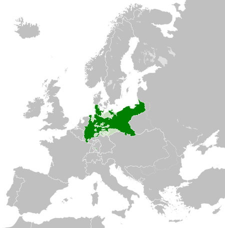
Файл:Kingdom of Prussia 1870.svg

Size of this PNG preview of this SVG file: 450 × 456 пиксел. Бусад зургын нягтрал: 237 × 240 пиксел | 474 × 480 пиксел | 758 × 768 пиксел | 1,011 × 1,024 пиксел | 2,021 × 2,048 пиксел.
Эх файл (SVG файл, 450 × 456 пиксэл, файлын хэмжээ: 705 КБ)
Товч агуулга
This W3C-unspecified vector image was created with Inkscape .


.svg)
.svg)
.svg)
.svg)
.svg)


.svg)
.svg)
.svg)


.png)
.png)


.svg)


.svg)

.svg)


.svg)
.svg)
.svg)
.svg)


.svg)
.png)


.svg)


.svg)
.svg)


.svg)


.svg)


.svg)
.svg)
.svg)
.svg)
.svg)
.svg)
.svg)
_cropped.svg)
.svg)
.svg)
.svg)
.svg)
.svg)
.svg)
.svg)
.svg)
.svg)
.svg)
.svg)
.svg)
.svg)
.svg)
.svg)
.svg)
.svg)
.svg)
.svg)
.svg)
.svg)
.svg)
.svg)
.svg)
.svg)
.svg)
.svg)
.svg)
.svg)
.svg)
.svg)
.svg)
.svg)
.svg)
.svg)
.svg)
.svg)
.svg)
.svg)
.svg)
.svg)
.svg)
.svg)
.svg)
.svg)
Лиценз
This file is licensed under the Creative Commons Attribution-Share Alike 4.0 International license.
- Та чөлөөтэй:
- хуваалцах – бүтээлийг хуулбарлах, түгээх, дамжуулах
- ремикс хийх – ажлыг тохируулах
- Дараах нөхцөлд:
- хамаарал – Та зохих кредитийг өгч, лицензийн холбоосыг өгч, өөрчлөлт оруулсан эсэхийг зааж өгөх ёстой. Та үүнийг ямар ч боломжийн аргаар хийж болно, гэхдээ лиценз олгогч таныг эсвэл таны хэрэглээг зөвшөөрөхгүй.
- адилхан хуваалцах – Хэрэв та материалыг дахин найруулах, хувиргах эсвэл бүтээх юм бол same or compatible license-ийн дагуу өөрийн хувь нэмрийг эх хувьтай нь түгээх ёстой.
Файлын түүх
Огноо/цаг дээр дарж тухайн үеийнх нь файлын байдлыг харна уу.
| Огноо/Цаг | Жижиг зураг | Хэмжээ | Хэрэглэгч | Тайлбар | |
|---|---|---|---|---|---|
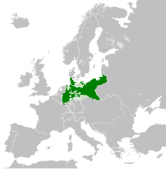
| одоогийн | 02:54, 1 Зургаадугаар сар 2016 | | 450 × 456 (705 КБ) | Alphathon | Various corrections to the states of the North German Confederation |
| 05:22, 31 Тавдугаар сар 2016 |  | 450 × 456 (662 КБ) | Alphathon | Minor corrections (Tarasp and post-1818 German Confederation border change) | |
| 02:40, 31 Тавдугаар сар 2016 |  | 450 × 456 (662 КБ) | Alphathon | == {{int:filedesc}} == {{Inkscape}} {{Information |Description={{en|A map of the en:Kingdom of Prussia within the North German Confederation and within Europe circa 1870 CE.}} |Source= {{Derived from|Blank_map_of_Europe.svg|display=50}} |Da... |
Холбоос
Дараахь хуудсууд уг файлтай холбогдсон байна:
Файлын хэрэглээ (бүх төсөл)
Дараах бусад вики энэ файлыг ашигладаг:
- af.wiktionary.org дахь хэрэглээ
- ar.wikipedia.org дахь хэрэглээ
- bn.wikipedia.org дахь хэрэглээ
- ckb.wikipedia.org дахь хэрэглээ
- en.wikipedia.org дахь хэрэглээ
- eo.wiktionary.org дахь хэрэглээ
- es.wikipedia.org дахь хэрэглээ
- es.wiktionary.org дахь хэрэглээ
- eu.wikipedia.org дахь хэрэглээ
- fa.wikipedia.org дахь хэрэглээ
- fi.wikipedia.org дахь хэрэглээ
- he.wikipedia.org дахь хэрэглээ
- hu.wikipedia.org дахь хэрэглээ
- is.wikipedia.org дахь хэрэглээ
- it.wikipedia.org дахь хэрэглээ
- li.wiktionary.org дахь хэрэглээ
- lld.wikipedia.org дахь хэрэглээ
- lt.wikipedia.org дахь хэрэглээ
- pl.wikipedia.org дахь хэрэглээ
- rue.wikipedia.org дахь хэрэглээ
- ru.wikipedia.org дахь хэрэглээ
- ru.wiktionary.org дахь хэрэглээ
- sk.wikipedia.org дахь хэрэглээ
- szl.wikipedia.org дахь хэрэглээ
- tr.wikipedia.org дахь хэрэглээ
- uk.wikipedia.org дахь хэрэглээ
- uz.wikipedia.org дахь хэрэглээ
- xmf.wikipedia.org дахь хэрэглээ
- zh.wikipedia.org дахь хэрэглээ