Файл:Yeniseirivermap.png
Үзлэгийн хэмжээ : 601 × 600 пиксел Бусад зургын нягтрал: 240 × 240 пиксел | 481 × 480 пиксел | 988 × 986 пиксел.
Эх файл (988 × 986 пиксел, файлын хэмжээ: 325 КБ, MIME төрөл: image/png)

|
This map image could be re-created using vector graphics as an SVG file. This has several advantages; see Commons:Media for cleanup for more information. If an SVG form of this image is available, please upload it and afterwards replace this template with
{{vector version available|new image name}}.
It is recommended to name the SVG file “Yeniseirivermap.svg”—then the template Vector version available (or Vva) does not need the new image name parameter. |
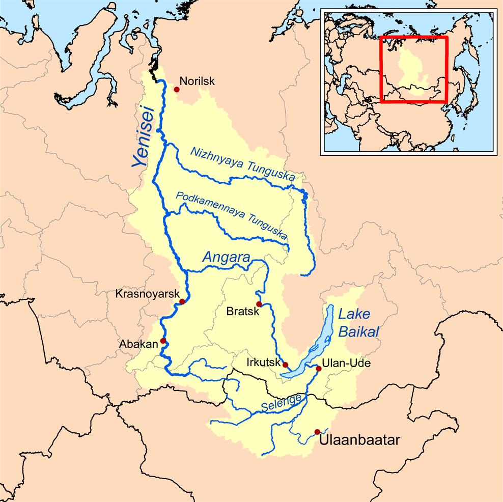
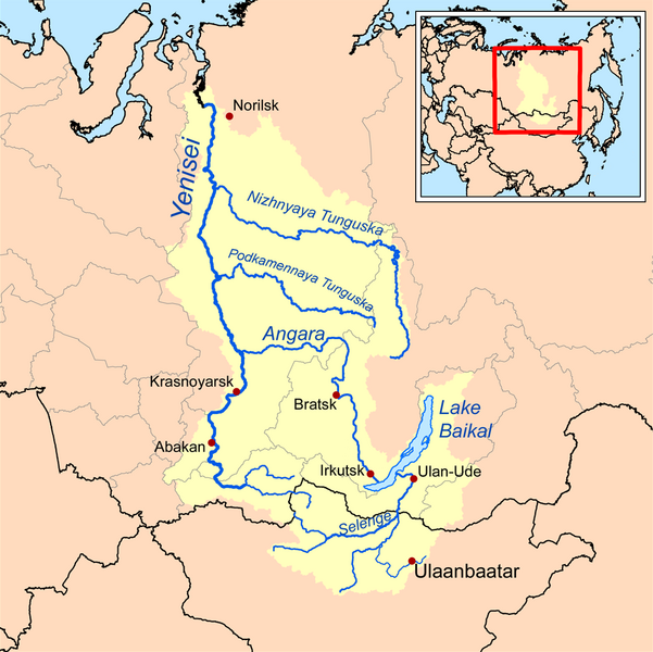
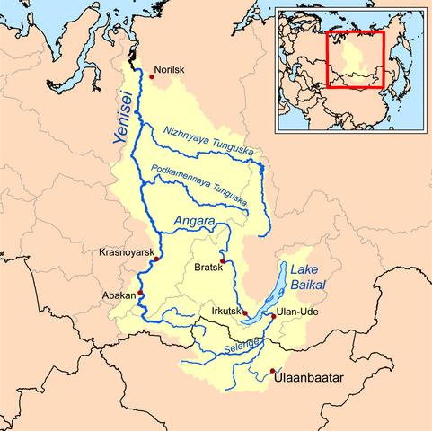
| Тайлбар | This is a map of the Yenisei River drainage basin, with national borders added. |
| Огноо | |
| Эх үүсвэр | Own work using Digital Chart of the World and GTOPO data. |
| Зохиогч | Kmusser |
|
|
This map image could be re-created using vector graphics as an SVG file. This has several advantages; see Commons:Media for cleanup for more information. If an SVG form of this image is available, please upload it and afterwards replace this template with
{{vector version available|new image name}}.
It is recommended to name the SVG file “Yeniseirivermap.svg”—then the template Vector version available (or Vva) does not need the new image name parameter. |
I, the copyright holder of this work, hereby publish it under the following license:
Энэ файл нь Creative Commons Attribution-Share Alike 3.0 Unported лицензтэй байна.
- Та чөлөөтэй:
- хуваалцах – бүтээлийг хуулбарлах, түгээх, дамжуулах
- ремикс хийх – ажлыг тохируулах
- Дараах нөхцөлд:
- хамаарал – Та зохих кредитийг өгч, лицензийн холбоосыг өгч, өөрчлөлт оруулсан эсэхийг зааж өгөх ёстой. Та үүнийг ямар ч боломжийн аргаар хийж болно, гэхдээ лиценз олгогч таныг эсвэл таны хэрэглээг зөвшөөрөхгүй.
- адилхан хуваалцах – Хэрэв та материалыг дахин найруулах, хувиргах эсвэл бүтээх юм бол same or compatible license-ийн дагуу өөрийн хувь нэмрийг эх хувьтай нь түгээх ёстой.
See also
Файлын түүх
Огноо/цаг дээр дарж тухайн үеийнх нь файлын байдлыг харна уу.
| Огноо/Цаг | Жижиг зураг | Хэмжээ | Хэрэглэгч | Тайлбар | |
|---|---|---|---|---|---|
| одоогийн | 13:32, 26 Аравдугаар сар 2013 | | 988 × 986 (325 КБ) | Ras67 | cropped, opt. |
| 18:10, 15 Есдүгээр сар 2008 |  | 1,000 × 1,000 (414 КБ) | Kmusser | {{Information |Description=This is a map of the Yenisei River drainage basin. |Source=Own work using http://www.maproom.psu.edu/dcw/ Digital Chart of the World and [[http://edc.usgs.gov/products/elevation/gtopo30/gtopo30.html GTO |
Холбоос
Дараахь хуудсууд уг файлтай холбогдсон байна:
Файлын хэрэглээ (бүх төсөл)
Дараах бусад вики энэ файлыг ашигладаг:
- af.wikipedia.org дахь хэрэглээ
- am.wikipedia.org дахь хэрэглээ
- ar.wikipedia.org дахь хэрэглээ
- arz.wikipedia.org дахь хэрэглээ
- ast.wikipedia.org дахь хэрэглээ
- azb.wikipedia.org дахь хэрэглээ
- be.wikipedia.org дахь хэрэглээ
- bh.wikipedia.org дахь хэрэглээ
- bn.wikipedia.org дахь хэрэглээ
- bs.wikipedia.org дахь хэрэглээ
- ca.wikipedia.org дахь хэрэглээ
- cs.wikipedia.org дахь хэрэглээ
- cy.wikipedia.org дахь хэрэглээ
- da.wikipedia.org дахь хэрэглээ
- de.wikipedia.org дахь хэрэглээ
- en.wikipedia.org дахь хэрэглээ
- Lake Baikal
- Angara
- Yenisey
- Nizhnyaya Tunguska
- New Order (Nazism)
- Soyot
- User:Kmusser/Images
- Tungusic peoples
- Dené–Yeniseian languages
- List of Russian explorers
- Demid Pyanda
- Wikipedia:Graphics Lab/Illustration workshop/Archive/Jan 2011
- Axis powers negotiations on the division of Asia
- Physochlaina
- Yenisei Inscriptions
- eo.wikipedia.org дахь хэрэглээ
Энэ файлын дэлхийн хэрэглээг харах.