Файл:Xinjiang nationalities by prefecture 2000.png

Үзлэгийн хэмжээ : 725 × 600 пиксел Бусад зургын нягтрал: 290 × 240 пиксел | 581 × 480 пиксел | 929 × 768 пиксел | 1,238 × 1,024 пиксел | 1,474 × 1,219 пиксел.
Эх файл (1,474 × 1,219 пиксел, файлын хэмжээ: 129 КБ, MIME төрөл: image/png)

|
This ethnographic map image could be re-created using vector graphics as an SVG file. This has several advantages; see Commons:Media for cleanup for more information. If an SVG form of this image is available, please upload it and afterwards replace this template with
{{vector version available|new image name}}.
It is recommended to name the SVG file “Xinjiang nationalities by prefecture 2000.svg”—then the template Vector version available (or Vva) does not need the new image name parameter. |
Товч агуулга
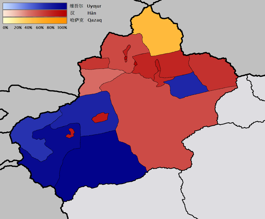
English: Map of the prefecture-level divisions of Xinjiang by ethnicity (nationality or 民族). 2000 census information is from w:en and w:de. The basis of the map is Image:Bayin Gholin.png, but I rotated the map so that the meridians are more nearly vertical, and also removed the background noise. I borrowed the colour scale from the Image:Canada election 2006 v2.png. QuartierLatin1968 21:20, 28 January 2006 (UTC)
Türkçe: Sincan'ın il düzeyi bölgelerindeki çoğunluğu oluşturan farklı etnik gruplar (minzu 民族). 2000 yılı nüfus verileri w:en ve w:de'den kaynaklanır. Haritanın temeli Image:Bayin Gholin.png'den alınmıştır, fakat meridyenleri daha dikey şekilde göstermek için harita döndürülmüştür ve gereksiz arka plan detayları çıkarılmıştır. Renk şeması Image:Canada election 2006 v2.png'den alınmıştır.
中文:新疆地域按民族(民族或民族)劃分的地圖。 2000年的人口普查信息來自w:en和w:de。 該地圖的基礎是Image:Bayin Gholin.png,但是我旋轉了地圖,使子午線更加接近垂直,並且還消除了背景噪音。 我從Image:Canada election 2006 v2.png中藉用了色階。 QuartierLatin196821:20,2006年1月28日(UTC)
Лиценз
I, the copyright holder of this work, hereby publish it under the following licenses:

|
Энэхүү баримт бичгийг GNU Free Documentation License, Хувилбарын нөхцлийн дагуу хуулах, түгээх болон/эсвэл өөрчлөх зөвшөөрөл олгосон. 1.2 эсвэл Чөлөөт програм хангамжийн сангаас нийтэлсэн дараагийн хувилбар; Инвариант хэсэггүй, нүүрэн талын текстгүй, арын хавтастай текстгүй. Лицензийн хуулбарыг GNU Free Documentation License гэсэн хэсэгт оруулсан болно. |
| Энэ файл нь Creative Commons Attribution-Share Alike 3.0 Unported лицензтэй байна. | ||
| ||
| This licensing tag was added to this file as part of the GFDL licensing update. |
This file is licensed under the Creative Commons Attribution-Share Alike 2.5 Generic, 2.0 Generic and 1.0 Generic license.
- Та чөлөөтэй:
- хуваалцах – бүтээлийг хуулбарлах, түгээх, дамжуулах
- ремикс хийх – ажлыг тохируулах
- Дараах нөхцөлд:
- хамаарал – Та зохих кредитийг өгч, лицензийн холбоосыг өгч, өөрчлөлт оруулсан эсэхийг зааж өгөх ёстой. Та үүнийг ямар ч боломжийн аргаар хийж болно, гэхдээ лиценз олгогч таныг эсвэл таны хэрэглээг зөвшөөрөхгүй.
- адилхан хуваалцах – Хэрэв та материалыг дахин найруулах, хувиргах эсвэл бүтээх юм бол same or compatible license-ийн дагуу өөрийн хувь нэмрийг эх хувьтай нь түгээх ёстой.
Та өөрийн хүссэн лицензээ сонгож болно.
Файлын түүх
Огноо/цаг дээр дарж тухайн үеийнх нь файлын байдлыг харна уу.
| Огноо/Цаг | Жижиг зураг | Хэмжээ | Хэрэглэгч | Тайлбар | |
|---|---|---|---|---|---|
| одоогийн | 21:43, 28 Нэгдүгээр сар 2006 | | 1,474 × 1,219 (129 КБ) | QuartierLatin1968 | adjusted Xizang/Qinghai boundary |
| 21:20, 28 Нэгдүгээр сар 2006 |  | 1,474 × 1,219 (129 КБ) | QuartierLatin1968 | * {{en}}: Map of the prefecture-level divisions of Xinjiang by ethnicity (nationality or 民族). 2000 census information is from w:en and w:de. The basis of the map is Image:Bayin Golin.png, but I rotated the map so that the meridians |
Холбоос
Файлын хэрэглээ (бүх төсөл)
Дараах бусад вики энэ файлыг ашигладаг:
- af.wikipedia.org дахь хэрэглээ
- ast.wikipedia.org дахь хэрэглээ
- azb.wikipedia.org дахь хэрэглээ
- az.wikipedia.org дахь хэрэглээ
- ba.wikipedia.org дахь хэрэглээ
- bcl.wikipedia.org дахь хэрэглээ
- bg.wikipedia.org дахь хэрэглээ
- ca.wikipedia.org дахь хэрэглээ
- da.wikipedia.org дахь хэрэглээ
- de.wikipedia.org дахь хэрэглээ
- en.wikipedia.org дахь хэрэглээ
- eo.wikipedia.org дахь хэрэглээ
- es.wikipedia.org дахь хэрэглээ
- fr.wikipedia.org дахь хэрэглээ
- gl.wikipedia.org дахь хэрэглээ
- hr.wikipedia.org дахь хэрэглээ
- incubator.wikimedia.org дахь хэрэглээ
- ja.wikipedia.org дахь хэрэглээ
- kk.wikipedia.org дахь хэрэглээ
- la.wikipedia.org дахь хэрэглээ
- lez.wikipedia.org дахь хэрэглээ
- lv.wikipedia.org дахь хэрэглээ
- ms.wikipedia.org дахь хэрэглээ
- nl.wikipedia.org дахь хэрэглээ
- nn.wikipedia.org дахь хэрэглээ
- no.wikipedia.org дахь хэрэглээ
- oc.wikipedia.org дахь хэрэглээ
- pt.wikipedia.org дахь хэрэглээ
- ru.wikipedia.org дахь хэрэглээ
- sr.wikipedia.org дахь хэрэглээ
Энэ файлын дэлхийн хэрэглээг харах.