Файл:Spratly with flags.jpg
Эх файл (962 × 741 пиксел, файлын хэмжээ: 94 КБ, MIME төрөл: image/jpeg)

|
This locator map image could be re-created using vector graphics as an SVG file. This has several advantages; see Commons:Media for cleanup for more information. If an SVG form of this image is available, please upload it and afterwards replace this template with
{{vector version available|new image name}}.
It is recommended to name the SVG file “Spratly with flags.svg”—then the template Vector version available (or Vva) does not need the new image name parameter. |


| Тайлбар |
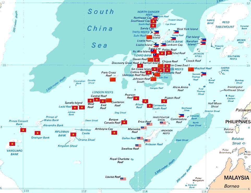
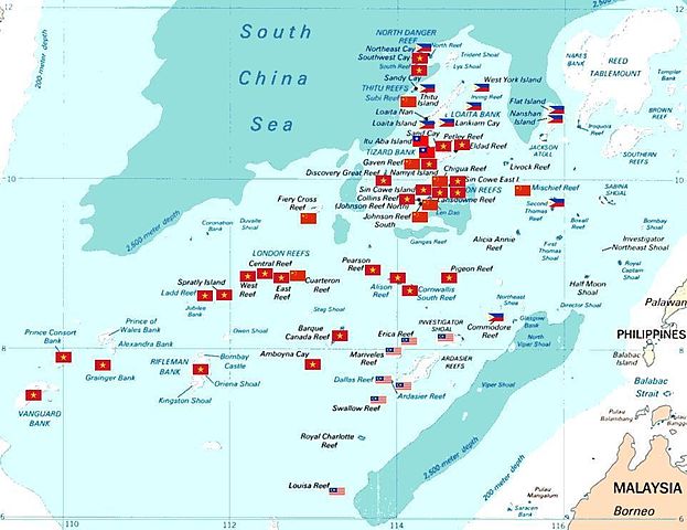
Spratly islands map showing occupied features marked with the flags of countries occupying them.
Kennan Reef (C) The flag nearest the flag for Johnson South Reef (C). |
||||||
| Огноо | (Original Picture), February 3, 2008 (Modified Picture) | ||||||
| Эх үүсвэр | Central Intelligence Agency. | ||||||
| Зохиогч | CIA. Cropped and Flags added by Estarapapax. | ||||||
| Зөвшөөрөл (Энэ файлыг дахин ашиглах) |
|
||||||

Файлын түүх
Огноо/цаг дээр дарж тухайн үеийнх нь файлын байдлыг харна уу.
| Огноо/Цаг | Жижиг зураг | Хэмжээ | Хэрэглэгч | Тайлбар | |
|---|---|---|---|---|---|
| одоогийн | 05:38, 25 Гуравдугаар сар 2008 | | 962 × 741 (94 КБ) | KAVO | {{Information |Description=Spratly islands map showing occupied features marked with the flags of countries occupying them. <br>{{flagicon|Philippines}} Philippines <br>{{flagicon|Taiwan}} Taiwan <br>{{flagicon|Vietnam}} Vietnam <br>{{flagicon|Malaysia}} |
Холбоос
Дараахь хуудсууд уг файлтай холбогдсон байна:
Файлын хэрэглээ (бүх төсөл)
Дараах бусад вики энэ файлыг ашигладаг:
- az.wikipedia.org дахь хэрэглээ
- bg.wikipedia.org дахь хэрэглээ
- ceb.wikipedia.org дахь хэрэглээ
- cs.wikipedia.org дахь хэрэглээ
- da.wikipedia.org дахь хэрэглээ
- de.wikipedia.org дахь хэрэглээ
- en.wikipedia.org дахь хэрэглээ
- es.wikipedia.org дахь хэрэглээ
- et.wikipedia.org дахь хэрэглээ
- fr.wikipedia.org дахь хэрэглээ
- hi.wikipedia.org дахь хэрэглээ
- id.wikipedia.org дахь хэрэглээ
- ja.wikipedia.org дахь хэрэглээ
Энэ файлын дэлхийн хэрэглээг харах.