Файл:Saint Chely Tarn.jpg
Үзлэгийн хэмжээ : 800 × 360 пиксел Бусад зургын нягтрал: 320 × 144 пиксел | 640 × 288 пиксел | 1,024 × 461 пиксел | 1,280 × 577 пиксел | 2,560 × 1,153 пиксел | 6,609 × 2,977 пиксел.
Эх файл (6,609 × 2,977 пиксел, файлын хэмжээ: 13.36 МБ, MIME төрөл: image/jpeg)
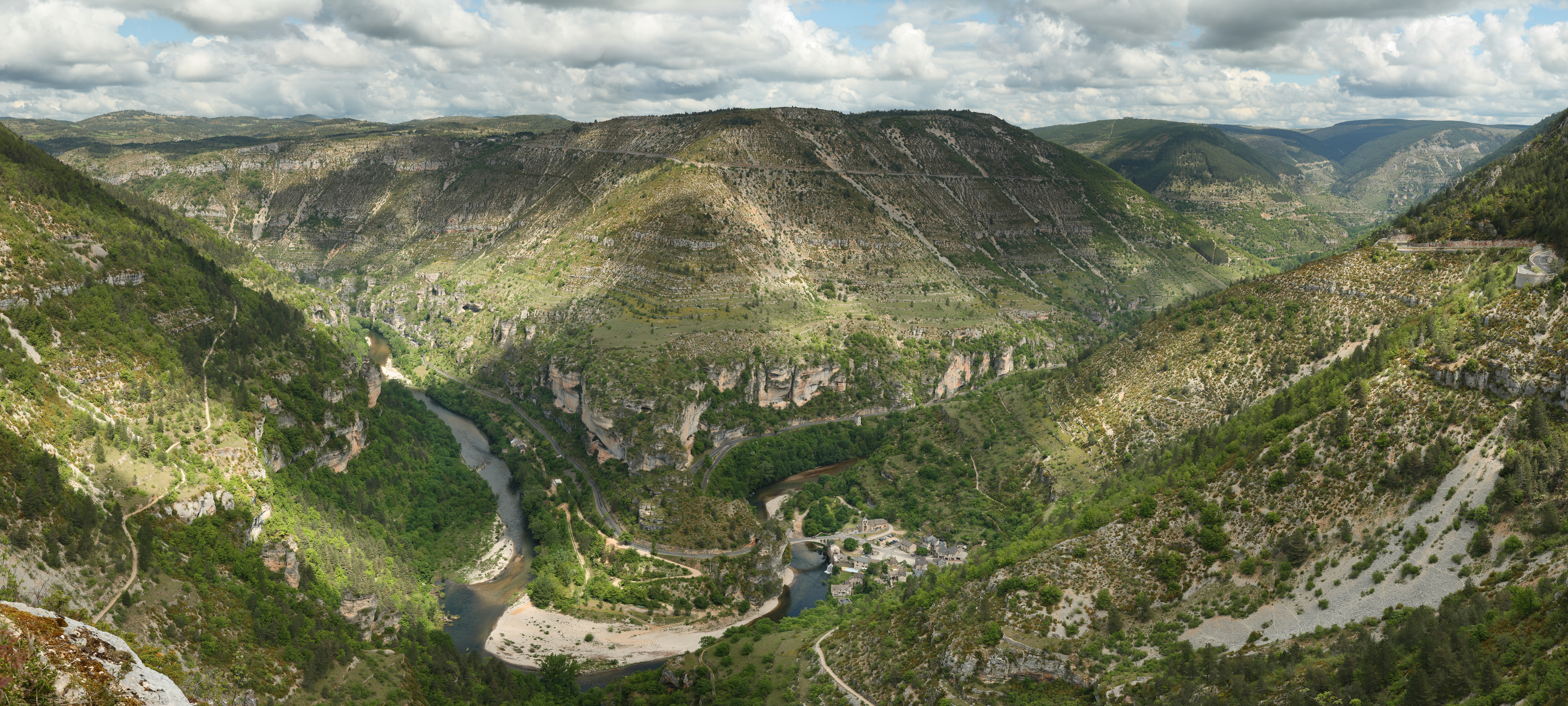
This image was selected as picture of the day on Wikimedia Commons for 13 February 2010. It was captioned as follows: English: View over the cirque of Pougnadoires and Saint-Chély-du-Tarn village, in the Tarn Gorges, from the cirque of Saint-Chély, France. Other languages:
Bosanski: Pogled preko cirka Pougnadoires i sela Saint-Chély-du-Tarn, u kanjonu rijeke Tarn, iz cirka Saint-Chély, Francuska Català: Vista del circ glacial de Pougnadoires, en les gorgues del Tarn, al municipi occità de Santa Enimia, França. Dansk: Udsigt over kedeldalen Pougnadoires og landsbyen Saint-Chély-du-Tarn i Gorges du Tarn i Cevennerne i Frankrig. Deutsch: Die Gorges du Tarn mit dem Dorf Saint-Chély-du-Tarn English: View over the cirque of Pougnadoires and Saint-Chély-du-Tarn village, in the Tarn Gorges, from the cirque of Saint-Chély, France. Español: Vista del circo glaciar de Pougnadoires y del pueblo de Saint-Chély-du-Tarn, en las gargantas del rio Tarn, Francia. Français : Vue du cirque de Pougnadoires et du village de Saint-Chély-du-Tarn, dans les gorges du Tarn, France. Italiano: Panoramica del circo glaciale del Pougnadoires e del villaggio di Saint-Chély-du-Tarn, nelle Gole del Tarn, in Francia. Magyar: A Tarn folyó szurdokvölgyének panorámaképe a languedoc-roussilloni Saint-Chély-du-Tarn település közelében Nederlands: Gezicht over het keteldal (cirque) van de Franse dorpen Pougnadoires en Saint-Chély-du-Tarn in de Gorges du Tarn, gezien vanaf het keteldal van Saint-Chély Polski: Widok na dolinę rzeki Tarn we Francji. Svenska: Byn Saint-Chély-du-Tarn vid floden Tarns dalgång i Frankrike. Русский: Вид горного цирка Пуньядуар и села Сен-Шели-дю-Тарн, которое лежит в долине реки Тарн, Франция Українська: Вигляд гірського цирку Пундуар і села Сент-Шелі-дю-Тарн, яке лежить в тіснині річки Тарн, Франція. বাংলা : ফ্রান্সের টার্ন গর্জেসে অবস্থিত সেই শিলে দু-টার্ন গ্রামের একটি দৃশ্য। 中文: 法国塔尔恩峽谷普格纳杜瓦勒和塔尔恩的圣谢里村风景 中文(繁體): 法國塔爾恩峽谷普格納杜瓦勒和塔爾恩的聖謝里村風景 |
|
Товч агуулга
| Тайлбар |
English: View over the cirque of Pougnadoires and Saint-Chély-du-Tarn village, in the Tarn Gorges, from the cirque of Saint-Chély. This picture features the road D 907bis which goes alongside the Tarn river all along the gorges. This picture is a mosaic of 14 pictures taken at 43mm, f/8.0, 1/250s and ISO 100. Stitching was done with Hugin and Enblend. Resulting hozirontal FOV is 118°.
Français : Vue du cirque de Pougnadoires et du village de Saint-Chély-du-Tarn, dans les gorges du Tarn. Cette photo a été prise d'un belvédère du bord de la D986, sur le cirque de Saint-Chély. On aperçoit sur le bas du versant opposé la départementale 907bis qui longe le Tarn dans ses gorges par la rive droite. Cette image a été réalisée à partir de 14 photos prises à 43mm, f/8.0, 1/250s et ISO 100. Le collage a été réalisé avec Hugin et Enblend. Le champ de vision horizontal résultant est de 118°. |
| Огноо | |
| Эх үүсвэр | Энэ миний бүтээл |
| Зохиогч | Benh LIEU SONG |
| Camera location | | View this and other nearby images on: OpenStreetMap |
|---|
Лиценз
I, the copyright holder of this work, hereby publish it under the following license:
Энэ файл нь Creative Commons Attribution-Share Alike 3.0 Unported лицензтэй байна.
- Та чөлөөтэй:
- хуваалцах – бүтээлийг хуулбарлах, түгээх, дамжуулах
- ремикс хийх – ажлыг тохируулах
- Дараах нөхцөлд:
- хамаарал – Та зохих кредитийг өгч, лицензийн холбоосыг өгч, өөрчлөлт оруулсан эсэхийг зааж өгөх ёстой. Та үүнийг ямар ч боломжийн аргаар хийж болно, гэхдээ лиценз олгогч таныг эсвэл таны хэрэглээг зөвшөөрөхгүй.
- адилхан хуваалцах – Хэрэв та материалыг дахин найруулах, хувиргах эсвэл бүтээх юм бол same or compatible license-ийн дагуу өөрийн хувь нэмрийг эх хувьтай нь түгээх ёстой.
Файлын түүх
Огноо/цаг дээр дарж тухайн үеийнх нь файлын байдлыг харна уу.
| Огноо/Цаг | Жижиг зураг | Хэмжээ | Хэрэглэгч | Тайлбар | |
|---|---|---|---|---|---|
| одоогийн | 18:12, 12 Наймдугаар сар 2008 | | 6,609 × 2,977 (13.36 МБ) | Benh | Changed colors. I believe this is more true to what I saw. |
| 22:56, 7 Зургаадугаар сар 2008 |  | 6,609 × 2,970 (9.59 МБ) | Benh | {{Information |Description={{en|1=View over the cirque of Pougnadoire and Saint-Chély of Tarn village, in the Tarn Gorges, from the cirque of Saint-Chély. This picture features the road D 907bis which goes alongside the Tarn river all along the gorges.} |
Холбоос
Дараахь хуудсууд уг файлтай холбогдсон байна:
Файлын хэрэглээ (бүх төсөл)
Дараах бусад вики энэ файлыг ашигладаг:
- ar.wikipedia.org дахь хэрэглээ
- az.wikipedia.org дахь хэрэглээ
- bn.wikipedia.org дахь хэрэглээ
- ceb.wikipedia.org дахь хэрэглээ
- crh.wikipedia.org дахь хэрэглээ
- cs.wikipedia.org дахь хэрэглээ
- cv.wikipedia.org дахь хэрэглээ
- de.wikipedia.org дахь хэрэглээ
- de.wikivoyage.org дахь хэрэглээ
- el.wikipedia.org дахь хэрэглээ
- en.wikipedia.org дахь хэрэглээ
- Lozère
- Massif Central
- Wikipedia:Featured pictures/Places/Panorama
- User talk:Blieusong
- Wikipedia:Featured pictures thumbs/12
- Wikipedia:Picture peer review/Archives/Apr-Jun 2008
- Saint-Chély-du-Tarn
- Wikipedia:Picture peer review/Saint Chely Tarn
- Wikipedia:Featured picture candidates/Saint Chely Tarn
- Wikipedia:Featured picture candidates/July-2008
- Wikipedia:Wikipedia Signpost/2008-07-07/Features and admins
- Wikipedia:Wikipedia Signpost/2008-07-07/SPV
- Wikipedia:Picture of the day/December 2008
- Template:POTD/2008-12-27
- Portal:Roads/Selected panorama
- Portal:Roads/Selected panorama/8
- User talk:Mostlyharmless/Archive 2
- Wikipedia:Wikipedia Signpost/Single/2008-07-07
- eo.wikipedia.org дахь хэрэглээ
- es.wikipedia.org дахь хэрэглээ
- fr.wikipedia.org дахь хэрэглээ
- fr.wikivoyage.org дахь хэрэглээ
Энэ файлын дэлхийн хэрэглээг харах.