Файл:Pyrenees topographic map-de.svg

Size of this PNG preview of this SVG file: 800 × 475 пиксел. Бусад зургын нягтрал: 320 × 190 пиксел | 640 × 380 пиксел | 1,024 × 608 пиксел | 1,280 × 760 пиксел | 2,560 × 1,520 пиксел | 3,200 × 1,900 пиксел.
Эх файл (SVG файл, 3,200 × 1,900 пиксэл, файлын хэмжээ: 6.3 МБ)
Товч агуулга
| Тайлбар |
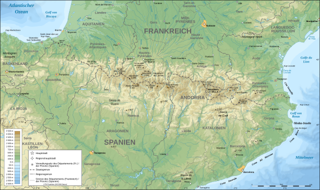
Deutsch: Topografische Karte der Pyrenäen in Deutsch.
English: Topographic map in German of the Pyrenees mountains.
Note: The shaded relief is a raster image embedded in the SVG file. Français : Carte topographique des Pyrénées en allemand.
Note : Le relief ombré est une image bitmap embarquée dans le fichier SVG. UTM projection; WGS84 datum; shaded relief (composite image of N-W, W and N lightning positions);
|
| Огноо | |
| Эх үүсвэр |
Image:Pyrenees_topographic_map-fr.svg
This W3C-unspecified vector image was created with Inkscape . |
| Зохиогч | Eric Gaba (Sting - fr:Sting) |
| Зөвшөөрөл (Энэ файлыг дахин ашиглах) |
Attribution and Share-Alike required |
| Other versions |
[]
|


|
This SVG file contains embedded text that can be translated into your language, using any capable SVG editor, text editor or the SVG Translate tool. For more information see: About translating SVG files. |
Лиценз
I, the copyright holder of this work, hereby publish it under the following licenses:

|
Энэхүү баримт бичгийг GNU Free Documentation License, Хувилбарын нөхцлийн дагуу хуулах, түгээх болон/эсвэл өөрчлөх зөвшөөрөл олгосон. 1.2 эсвэл Чөлөөт програм хангамжийн сангаас нийтэлсэн дараагийн хувилбар; Инвариант хэсэггүй, нүүрэн талын текстгүй, арын хавтастай текстгүй. Лицензийн хуулбарыг GNU Free Documentation License гэсэн хэсэгт оруулсан болно. |
| Энэ файл нь Creative Commons Attribution-Share Alike 3.0 Unported лицензтэй байна. | ||
| ||
| This licensing tag was added to this file as part of the GFDL licensing update. |
This file is licensed under the Creative Commons Attribution-Share Alike 2.5 Generic, 2.0 Generic and 1.0 Generic license.
- Та чөлөөтэй:
- хуваалцах – бүтээлийг хуулбарлах, түгээх, дамжуулах
- ремикс хийх – ажлыг тохируулах
- Дараах нөхцөлд:
- хамаарал – Та зохих кредитийг өгч, лицензийн холбоосыг өгч, өөрчлөлт оруулсан эсэхийг зааж өгөх ёстой. Та үүнийг ямар ч боломжийн аргаар хийж болно, гэхдээ лиценз олгогч таныг эсвэл таны хэрэглээг зөвшөөрөхгүй.
- адилхан хуваалцах – Хэрэв та материалыг дахин найруулах, хувиргах эсвэл бүтээх юм бол same or compatible license-ийн дагуу өөрийн хувь нэмрийг эх хувьтай нь түгээх ёстой.
Та өөрийн хүссэн лицензээ сонгож болно.
Файлын түүх
Огноо/цаг дээр дарж тухайн үеийнх нь файлын байдлыг харна уу.
| Огноо/Цаг | Жижиг зураг | Хэмжээ | Хэрэглэгч | Тайлбар | |
|---|---|---|---|---|---|
| одоогийн | 18:31, 23 Есдүгээр сар 2008 | | 3,200 × 1,900 (6.3 МБ) | Sting | Using ETOPO1 data for bathymetry; new standard colors |
| 01:30, 5 Наймдугаар сар 2007 |  | 3,200 × 1,900 (5.9 МБ) | J. Schwerdtfeger~commonswiki | == Summary == {{Information |Description= {{de|Topografische Karte der Pyrenäen in Deutsch.}} {{en|Topographic map in German of the Pyrenees mountains.}} {{fr|Carte topographique des Pyrénées en all |
Холбоос
Дараахь хуудсууд уг файлтай холбогдсон байна:
Файлын хэрэглээ (бүх төсөл)
Дараах бусад вики энэ файлыг ашигладаг:
- als.wikipedia.org дахь хэрэглээ
- de.wikipedia.org дахь хэрэглээ
- frr.wikipedia.org дахь хэрэглээ