Файл:Panama-Canal-rough-diagram-quick.jpg
Үүнээс илүү чанартай хувилбар байхгүй байна.
Panama-Canal-rough-diagram-quick.jpg (560 × 540 пиксел, файлын хэмжээ: 57 КБ, MIME төрөл: image/jpeg)
Товч агуулга
| Тайлбар |
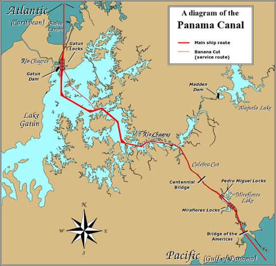
English: A diagram illustrating the layout of the Panama Canal (in quick JPEG format, auto-resizes to fit).
Due to the shape of the Isthmus of Panama, the Pacific end of the canal is actually the south-east end, and the Caribbean / Atlantic end is at the north-west. From the Pacific side, the Miraflores and Pedro Miguel locks (with two and one stages respectively) lead up to the highest level of the canal, 26 metres (85 feet) above sea level. The Culebra Cut (or Gaillard Cut) leads to Gatún Lake, created by damming the Chagres River; then the Gatún Locks lead back down to sea level in Limón Bay. The heavy red line shows the ship route. The narrower red line in Gatún Lake is the Banana Cut, a shortcut used by canal boats and yachts. |
| Огноо | |
| Эх үүсвэр | Source URL: Image:Panama_Canal_Rough_Diagram.png (GFDL file, reduced/retouched, saved JPEG format (5x faster than PNG), intended for use in frequently-read Wiki articles). |
| Зохиогч | User:Johantheghost (JPEG version by Wikid77) |

|
This transport map image could be re-created using vector graphics as an SVG file. This has several advantages; see Commons:Media for cleanup for more information. If an SVG form of this image is available, please upload it and afterwards replace this template with
{{vector version available|new image name}}.
It is recommended to name the SVG file “Panama-Canal-rough-diagram-quick.svg”—then the template Vector version available (or Vva) does not need the new image name parameter. |


Лиценз

|
Энэхүү баримт бичгийг GNU Free Documentation License, Хувилбарын нөхцлийн дагуу хуулах, түгээх болон/эсвэл өөрчлөх зөвшөөрөл олгосон. 1.2 эсвэл Чөлөөт програм хангамжийн сангаас нийтэлсэн дараагийн хувилбар; Инвариант хэсэггүй, нүүрэн талын текстгүй, арын хавтастай текстгүй. Лицензийн хуулбарыг GNU Free Documentation License гэсэн хэсэгт оруулсан болно. |
| Энэ файл нь Creative Commons Attribution-Share Alike 3.0 Unported лицензтэй байна. | ||
| ||
| This licensing tag was added to this file as part of the GFDL licensing update. |
Файлын түүх
Огноо/цаг дээр дарж тухайн үеийнх нь файлын байдлыг харна уу.
| Огноо/Цаг | Жижиг зураг | Хэмжээ | Хэрэглэгч | Тайлбар | |
|---|---|---|---|---|---|
| одоогийн | 17:28, 26 Арванхоёрдугаар сар 2006 | | 560 × 540 (57 КБ) | Wikid77 | == Summary == A diagram illustrating the layout of the Panama Canal (in quick JPEG format, auto-resizes to fit). Due to the shape of the Isthmus of Panama, the Pacific |
Холбоос
Дараахь хуудсууд уг файлтай холбогдсон байна:
Файлын хэрэглээ (бүх төсөл)
Дараах бусад вики энэ файлыг ашигладаг:
- ar.wikipedia.org дахь хэрэглээ
- cdo.wikipedia.org дахь хэрэглээ
- cs.wikipedia.org дахь хэрэглээ
- de.wikipedia.org дахь хэрэглээ
- en.wikipedia.org дахь хэрэглээ
- es.wikipedia.org дахь хэрэглээ
- fi.wikipedia.org дахь хэрэглээ
- fr.wikipedia.org дахь хэрэглээ
- gor.wikipedia.org дахь хэрэглээ
- hu.wikipedia.org дахь хэрэглээ
- id.wikipedia.org дахь хэрэглээ
- jv.wikipedia.org дахь хэрэглээ
- km.wikipedia.org дахь хэрэглээ
- li.wikipedia.org дахь хэрэглээ
- map-bms.wikipedia.org дахь хэрэглээ
- min.wikipedia.org дахь хэрэглээ
- simple.wikipedia.org дахь хэрэглээ
- th.wikipedia.org дахь хэрэглээ
- ur.wikipedia.org дахь хэрэглээ
- vi.wikipedia.org дахь хэрэглээ
- www.wikidata.org дахь хэрэглээ
- zh.wikinews.org дахь хэрэглээ