Файл:North ossetia alania map.png

Үзлэгийн хэмжээ : 534 × 599 пиксел Бусад зургын нягтрал: 214 × 240 пиксел | 428 × 480 пиксел | 720 × 808 пиксел.
Эх файл (720 × 808 пиксел, файлын хэмжээ: 53 КБ, MIME төрөл: image/png)
Товч агуулга
| Тайлбар |
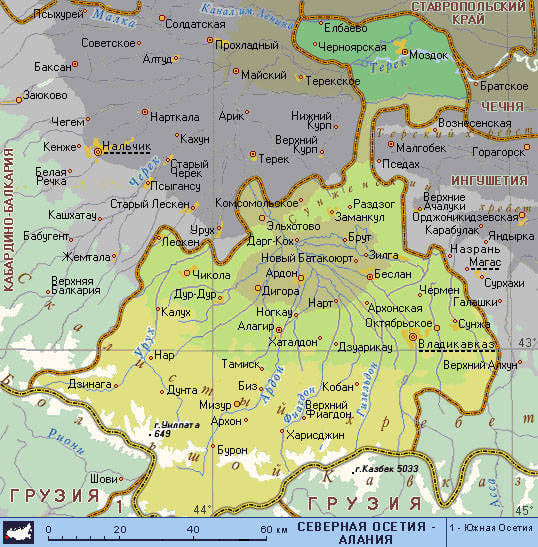
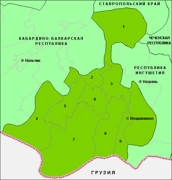
English: Map of the Republic of North Ossetia-Alania. |
| Огноо | |
| Эх үүсвэр | Энэ миний бүтээл |
| Зохиогч | PANONIAN |
Лиценз
I, the copyright holder of this work, hereby publish it under the following license:
| This file is made available under the Creative Commons CC0 1.0 Universal Public Domain Dedication. | |
| The person who associated a work with this deed has dedicated the work to the public domain by waiving all of their rights to the work worldwide under copyright law, including all related and neighboring rights, to the extent allowed by law. You can copy, modify, distribute and perform the work, even for commercial purposes, all without asking permission.
|
References
Maps from external links:
- http://www.skppk.ru/i/map/osetiya_region_map.jpg
- http://ossetians.com/pictures/Map_1.jpg
- http://topwar.ru/uploads/posts/2011-06/1309189225_alania_karta.jpg
- http://www.stopwatchhut.com/places/770.jpg
- http://nocss.ru/projects/10/images/map-1.jpg
- http://karty.narod.ru/maps/sosetia/s-osetia.GIF
- http://obkom.com/russia/fussr/osetiya-yuzhnaya/images/karta-osetia-sev-yuzh.jpg
- http://karta-russia.ru/maps/map-severnaya-osetiya-karta.jpg
- http://alcoinf.com/images/severnaya-osetiya.gif
- http://sif.ru/images/maps/Severnaya-Osetiya2.gif
- http://region15.ru/img/territor/map-adm.gif
- http://www.hge.pu.ru/mapgis/subekt/osetia/osetia.gif
- http://www.smsr-senclub.ru/upload/medialibrary/ece/ece341c19c79030e09063fff6763d2d5.jpg
- http://www.rossadovod.ru/regions/osetia-alania/map.jpg
- http://www.ntsomz.ru/img/severnaya%20osetiya_800x566.jpg
- http://trasa.ru/img/regions/sevosetiya.gif
- http://dic.academic.ru/pictures/enc_geo/Severnaya_Osetia-Alania.jpg
- http://geo.1september.ru/2008/22/40-1.jpg
- http://openbudget.karelia.ru/budnord/russian/north-caucasian/northern-ossetiya-republic/images/karta_alania.jpg
List of largest cities and towns:
Файлын түүх
Огноо/цаг дээр дарж тухайн үеийнх нь файлын байдлыг харна уу.
| Огноо/Цаг | Жижиг зураг | Хэмжээ | Хэрэглэгч | Тайлбар | |
|---|---|---|---|---|---|
| одоогийн | 06:51, 17 Зургаадугаар сар 2012 | | 720 × 808 (53 КБ) | PANONIAN | {{Information |Description ={{en|1=Map of the Republic of North Ossetia-Alania.}} |Source ={{own}} |Author =PANONIAN |Date =2012 |Permission = |other_versions = }} |
Холбоос
Дараахь хуудсууд уг файлтай холбогдсон байна:
Файлын хэрэглээ (бүх төсөл)
Дараах бусад вики энэ файлыг ашигладаг:
- ace.wikipedia.org дахь хэрэглээ
- ast.wikipedia.org дахь хэрэглээ
- az.wikipedia.org дахь хэрэглээ
- ba.wikipedia.org дахь хэрэглээ
- be-tarask.wikipedia.org дахь хэрэглээ
- be.wikipedia.org дахь хэрэглээ
- bg.wikipedia.org дахь хэрэглээ
- br.wikipedia.org дахь хэрэглээ
- bs.wikipedia.org дахь хэрэглээ
- bxr.wikipedia.org дахь хэрэглээ
- ce.wikipedia.org дахь хэрэглээ
- cs.wikipedia.org дахь хэрэглээ
- cv.wikipedia.org дахь хэрэглээ
- diq.wikipedia.org дахь хэрэглээ
- en.wikipedia.org дахь хэрэглээ
- es.wikipedia.org дахь хэрэглээ
- et.wikipedia.org дахь хэрэглээ
- eu.wikipedia.org дахь хэрэглээ
- fo.wikipedia.org дахь хэрэглээ
- ga.wikipedia.org дахь хэрэглээ
- gl.wikipedia.org дахь хэрэглээ
- got.wikipedia.org дахь хэрэглээ
- hy.wikipedia.org дахь хэрэглээ
- id.wikipedia.org дахь хэрэглээ
- is.wikipedia.org дахь хэрэглээ
- it.wikipedia.org дахь хэрэглээ
- ka.wikipedia.org дахь хэрэглээ
- kbd.wikipedia.org дахь хэрэглээ
- koi.wikipedia.org дахь хэрэглээ
- krc.wikipedia.org дахь хэрэглээ
- kv.wikipedia.org дахь хэрэглээ
- la.wikipedia.org дахь хэрэглээ
- lbe.wikipedia.org дахь хэрэглээ
- lmo.wikipedia.org дахь хэрэглээ
- lt.wikipedia.org дахь хэрэглээ
- mhr.wikipedia.org дахь хэрэглээ
- mr.wikipedia.org дахь хэрэглээ
- ms.wikipedia.org дахь хэрэглээ
- myv.wikipedia.org дахь хэрэглээ
- nn.wikipedia.org дахь хэрэглээ
- pnb.wikipedia.org дахь хэрэглээ
- ps.wikipedia.org дахь хэрэглээ
- ro.wikipedia.org дахь хэрэглээ
- rw.wikipedia.org дахь хэрэглээ
- sah.wikipedia.org дахь хэрэглээ
- scn.wikipedia.org дахь хэрэглээ
- sco.wikipedia.org дахь хэрэглээ
- se.wikipedia.org дахь хэрэглээ
- simple.wikipedia.org дахь хэрэглээ
Энэ файлын дэлхийн хэрэглээг харах.