Файл:Noord-Brabant position.svg

Size of this PNG preview of this SVG file: 200 × 236 пиксел. Бусад зургын нягтрал: 203 × 240 пиксел | 407 × 480 пиксел | 651 × 768 пиксел | 868 × 1,024 пиксел | 1,736 × 2,048 пиксел.
Эх файл (SVG файл, 200 × 236 пиксэл, файлын хэмжээ: 158 КБ)
Товч агуулга
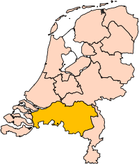
| Тайлбар | Location of the province of Noord-Brabant (North Brabant) in the Netherlands. |
| Огноо | |
| Эх үүсвэр | Own work, based on freely available GIS data |
| Зохиогч | User:Mtcv |
| Зөвшөөрөл (Энэ файлыг дахин ашиглах) |
Data: attribution required; my work: PD |
| Other versions | I attempted to make an svg version of Image:Noord Brabant-Position.png (with less simplified boundaries) |
Clickable version

Лиценз

|
The copyright holder of this file, Centraal Bureau voor de Statistiek, allows anyone to use it for any purpose, provided that the copyright holder is properly attributed. Redistribution, derivative work, commercial use, and all other use is permitted. |
Атрибут:
|
| Annotations | This image is annotated: View the annotations at Commons |


Файлын түүх
Огноо/цаг дээр дарж тухайн үеийнх нь файлын байдлыг харна уу.
| Огноо/Цаг | Жижиг зураг | Хэмжээ | Хэрэглэгч | Тайлбар | |
|---|---|---|---|---|---|
| одоогийн | 17:20, 2 Гуравдугаар сар 2019 | | 200 × 236 (158 КБ) | Thayts | update |
| 00:49, 3 Аравдугаар сар 2006 |  | 200 × 236 (158 КБ) | Mtcv | {{Information| |Description=Location of the province of Noord-Holland (North Holland) in the Netherlands. |Source=Own work, based on freely available GIS data |Date=2006-10-03 |Author=User:Mtcv |Permission=Data: attribution required; my work: PD |othe |
Холбоос
Энэ файлд холбоос хийсэн хуудас байхгүй байна.
Файлын хэрэглээ (бүх төсөл)
Дараах бусад вики энэ файлыг ашигладаг:
- ar.wikipedia.org дахь хэрэглээ
- شمال بربنت
- آيندهوفن
- بريدا
- بارله ناساو
- تيلبورخ
- سيرتوخيمبوس
- قالب:بلديات شمال برابنت
- آلبورخ
- ألفن- كام
- أستن
- بيرخ آيك
- فيلدهوفن
- بيرخن أوب زووم
- بيرنهيزه
- بيست (هولندا)
- بلادل
- بوكل
- بوكسمير
- بوكستل
- كرانندونك
- كاوك
- دورنه
- دونجن
- دريميلين
- إيرسل
- إيتن- لور
- خيرتراودنبيرخ
- خيلدروب- ميرلو
- خيميرت- باكل
- خيلزه آن راين
- خورلا
- خرافه (هولندا)
- هارن (شمال برابنت)
- هالدربيرخه
- هيزه- لينده
- هيلموند
- هوسدن
- هيلفارينبيك
- لاربيك
- لانديرد
- لوب أوب زند
- مل آن سينت هوبرت
- موردايك
- نونن (خيرفن آن نيدرفيتن)
- أويرشخوت
- أويسترفايك
- أوسترهاوت
- أوس (هولندا)
- روسل- دي ميردن
- روسيندال
Энэ файлын дэлхийн хэрэглээг харах.