Файл:Kapisa districts.png

Үзлэгийн хэмжээ : 786 × 600 пиксел Бусад зургын нягтрал: 315 × 240 пиксел | 629 × 480 пиксел | 1,000 × 763 пиксел.
Эх файл (1,000 × 763 пиксел, файлын хэмжээ: 17 КБ, MIME төрөл: image/png)

|
This map image could be re-created using vector graphics as an SVG file. This has several advantages; see Commons:Media for cleanup for more information. If an SVG form of this image is available, please upload it and afterwards replace this template with
{{vector version available|new image name}}.
It is recommended to name the SVG file “Kapisa districts.svg”—then the template Vector version available (or Vva) does not need the new image name parameter. |
Товч агуулга
| Тайлбар |
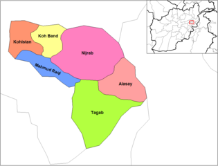
English: Map of the districts of Kapisa province of Afghanistan. Created by Rarelibra 19:26, 29 March 2007 (UTC) for public domain use, using MapInfo Professional v8.5 and various mapping resources. |
| Огноо | 29 Гуравдугаар сар 2007 (original upload date) |
| Эх үүсвэр | No machine-readable source provided. Own work assumed (based on copyright claims). |
| Зохиогч | No machine-readable author provided. Rarelibra assumed (based on copyright claims). |
Лиценз
| I, the copyright holder of this work, release this work into the public domain. This applies worldwide. In some countries this may not be legally possible; if so: I grant anyone the right to use this work for any purpose, without any conditions, unless such conditions are required by law. |
Файлын түүх
Огноо/цаг дээр дарж тухайн үеийнх нь файлын байдлыг харна уу.
| Огноо/Цаг | Жижиг зураг | Хэмжээ | Хэрэглэгч | Тайлбар | |
|---|---|---|---|---|---|
| одоогийн | 14:04, 15 Хоёрдугаар сар 2024 | | 1,000 × 763 (17 КБ) | User-duck | Cropped 5 % horizontally, 6 % vertically using CropTool with lossless mode. |
| 19:26, 29 Гуравдугаар сар 2007 |  | 1,056 × 816 (25 КБ) | Rarelibra | Map of the districts of Kapisa province of Afghanistan. Created by ~~~~ for public domain use, using MapInfo Professional v8.5 and various mapping resources. |
Холбоос
Дараахь хуудсууд уг файлтай холбогдсон байна:
Файлын хэрэглээ (бүх төсөл)
Дараах бусад вики энэ файлыг ашигладаг:
- ar.wikipedia.org дахь хэрэглээ
- bn.wikipedia.org дахь хэрэглээ
- ca.wikipedia.org дахь хэрэглээ
- da.wikipedia.org дахь хэрэглээ
- de.wikipedia.org дахь хэрэглээ
- en.wikipedia.org дахь хэрэглээ
- es.wikipedia.org дахь хэрэглээ
- fa.wikipedia.org дахь хэрэглээ
- fr.wikipedia.org дахь хэрэглээ
- he.wikipedia.org дахь хэрэглээ
- incubator.wikimedia.org дахь хэрэглээ
- it.wikipedia.org дахь хэрэглээ
- lt.wikipedia.org дахь хэрэглээ
- ms.wikipedia.org дахь хэрэглээ
- nl.wikipedia.org дахь хэрэглээ
- no.wikipedia.org дахь хэрэглээ
- pl.wikipedia.org дахь хэрэглээ
Энэ файлын дэлхийн хэрэглээг харах.