Файл:Empire of Theodoric the Great 523.gif

Empire_of_Theodoric_the_Great_523.gif(523 × 478 пиксел, файлын хэмжээ: 33 КБ, MIME төрөл: image/gif)

Энэ файл нь Wikimedia Commons-нх бөгөөд бусад төслүүд үүнийг хэрэглэх боломжтой. Доор файлын тайлбарын хуудсан дээрх тайлбарыг оруулсан байгаа:

Товч агуулга

Тайлбар
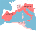
English: Map of the territories (pink) ruled by Theodoric the Great at their height in 523, when he annexed the southern part of the Burgundian kingdom, between the rivers Durance and Isere. Stippled areas indicate other kingdoms dominated by Theodoric at this time.
Огноо
Эх үүсвэр prepared from information in Wikipedia, Historical Atlases, and other books,in particular The Goths by Peter Heather
Зохиогч Howard Wiseman
Other versions based on a map at http://www.sci.gu.edu.au/~wiseman/Roman/5CompMaps.html

Лиценз

Vortimer at англи Википедиа, the copyright holder of this work, hereby publishes it under the following licenses:
GNU head Энэхүү баримт бичгийг GNU Free Documentation License, Хувилбарын нөхцлийн дагуу хуулах, түгээх болон/эсвэл өөрчлөх зөвшөөрөл олгосон. 1.2 эсвэл Чөлөөт програм хангамжийн сангаас нийтэлсэн дараагийн хувилбар; Инвариант хэсэггүй, нүүрэн талын текстгүй, арын хавтастай текстгүй. Лицензийн хуулбарыг GNU Free Documentation License гэсэн хэсэгт оруулсан болно.
w:en:Creative Commons
хамаарал
This file is licensed under the Creative Commons Attribution 3.0 Unported license.
Та чөлөөтэй:
  • хуваалцах – бүтээлийг хуулбарлах, түгээх, дамжуулах
  • ремикс хийх – ажлыг тохируулах
Дараах нөхцөлд:
  • хамаарал – Та зохих кредитийг өгч, лицензийн холбоосыг өгч, өөрчлөлт оруулсан эсэхийг зааж өгөх ёстой. Та үүнийг ямар ч боломжийн аргаар хийж болно, гэхдээ лиценз олгогч таныг эсвэл таны хэрэглээг зөвшөөрөхгүй.
Та өөрийн хүссэн лицензээ сонгож болно.

Original upload log

Transferred from en.wikipedia to Commons by Lazyhawk using CommonsHelper.

The original description page was here. All following user names refer to en.wikipedia.
  • 2007-12-28 04:23 Vortimer 523×478× (33298 bytes) {{Information |Description=Map of the territories (pink) ruled by Theodoric the Great at their height in 523, when he annexed the souther part of the Burgundian kingdom, between the rivers Durance and Isere. Stippled areas indicate other kin
  • 2007-12-27 12:01 Vortimer 523×478× (33484 bytes) {{Information |Description=Map of the territories (pink) ruled by Theodoric the Great at their height in 523, when he annexed the souther part of the Burgundian kingdom, between the rivers Durance and Isere. Stippled areas indicate other kingdoms dominate
  • 2007-12-27 11:57 Vortimer 523×478× (32320 bytes) {{Information |Description=Map of the territories (pink) ruled by Theodoric the Great at their height in 523, when he annexed the souther part of the Burgundian kingdom, between the rivers Durance and Isere. Stippled areas indicate other kingdoms dominate

Captions

Add a one-line explanation of what this file represents

Items portrayed in this file

depicts англи

copyright status англи

copyrighted англи

27 Арванхоёрдугаар сар 2007

Файлын түүх

Огноо/цаг дээр дарж тухайн үеийнх нь файлын байдлыг харна уу.

Огноо/ЦагЖижиг зурагХэмжээХэрэглэгчТайлбар
одоогийн13:15, 20 Арванхоёрдугаар сар 201113:15, 20 Арванхоёрдугаар сар 2011-н байдлаарх хувилбарын жижиг хувилбар523 × 478 (33 КБ)OgreBot(BOT): Reverting to most recent version before archival
13:15, 20 Арванхоёрдугаар сар 201113:15, 20 Арванхоёрдугаар сар 2011-н байдлаарх хувилбарын жижиг хувилбар523 × 478 (33 КБ)OgreBot(BOT): Uploading old version of file from en.wikipedia; originally uploaded on 2007-12-27 12:01:51 by Vortimer
13:15, 20 Арванхоёрдугаар сар 201113:15, 20 Арванхоёрдугаар сар 2011-н байдлаарх хувилбарын жижиг хувилбар523 × 478 (32 КБ)OgreBot(BOT): Uploading old version of file from en.wikipedia; originally uploaded on 2007-12-27 11:57:01 by Vortimer
01:55, 12 Есдүгээр сар 201101:55, 12 Есдүгээр сар 2011-н байдлаарх хувилбарын жижиг хувилбар523 × 478 (33 КБ)File Upload Bot (Magnus Manske) {{BotMoveToCommons|en.wikipedia|year={{subst:CURRENTYEAR}}|month={{subst:CURRENTMONTHNAME}}|day={{subst:CURRENTDAY}}}} {{Information |Description={{en|Map of the territories (pink) ruled by Theodoric the Great at their height in 523, when he annexed the

Энэ файлд холбоос хийсэн хуудас байхгүй байна.

Файлын хэрэглээ (бүх төсөл)

Дараах бусад вики энэ файлыг ашигладаг: