Файл:Eastern Front 1941-06 to 1941-12.png

Үзлэгийн хэмжээ : 783 × 600 пиксел Бусад зургын нягтрал: 313 × 240 пиксел | 627 × 480 пиксел | 1,003 × 768 пиксел | 1,201 × 920 пиксел.
Эх файл (1,201 × 920 пиксел, файлын хэмжээ: 330 КБ, MIME төрөл: image/png)

|
This military map image could be re-created using vector graphics as an SVG file. This has several advantages; see Commons:Media for cleanup for more information. If an SVG form of this image is available, please upload it and afterwards replace this template with
{{vector version available|new image name}}.
It is recommended to name the SVG file “Eastern Front 1941-06 to 1941-12.svg”—then the template Vector version available (or Vva) does not need the new image name parameter. |
Товч агуулга
| Тайлбар |
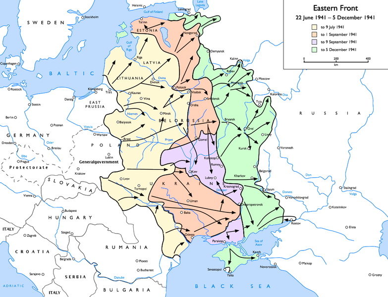
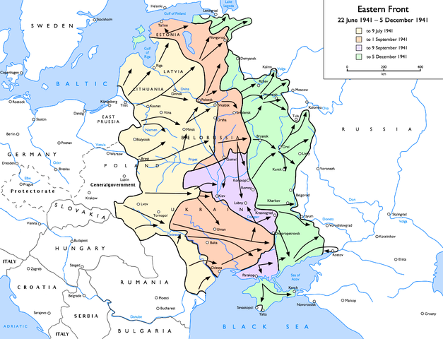
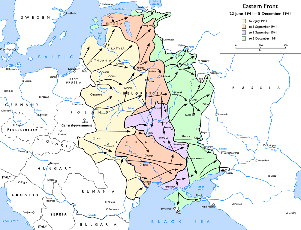
English: Map of the Eastern Front (WWII), 1941-06-21 to 1941-12-05
to 9 July 1941
to 1 September 1941
to 9 September 1941
to 5 December 1941 |
| Огноо | |
| Эх үүсвэр | Энэ миний бүтээл |
| Зохиогч | User:Gdr |
| Other versions |
[]
|


.png)


.jpg)
Лиценз
Gdr from en.wikipedia.org, the copyright holder of this work, hereby publishes it under the following license:
| Энэ файл нь Creative Commons Attribution-Share Alike 3.0 Unported лицензтэй байна. Subject to disclaimers. | ||
| Атрибут: Gdr from en.wikipedia.org | ||
| ||
| This licensing tag was added to this file as part of the GFDL licensing update. |

|
Энэхүү баримт бичгийг GNU Free Documentation License, Хувилбарын нөхцлийн дагуу хуулах, түгээх болон/эсвэл өөрчлөх зөвшөөрөл олгосон. 1.2 эсвэл Чөлөөт програм хангамжийн сангаас нийтэлсэн дараагийн хувилбар; Инвариант хэсэггүй, нүүрэн талын текстгүй, арын хавтастай текстгүй. Лицензийн хуулбарыг GNU Free Documentation License гэсэн хэсэгт оруулсан болно. Subject to disclaimers. |
Original upload log
Transferred from en.wikipedia to Commons by Sdrtirs using CommonsHelper.
The original description page was here. All following user names refer to en.wikipedia.
- 2007-07-05 11:44 Mahahahaneapneap 1201×920×8 (243537 bytes) pngcrushed
- 2007-06-29 22:34 Forteblast 1201×920×8 (333192 bytes) Reverted to earlier revision
- 2006-09-30 10:57 Felix116 1201×920×8 (333192 bytes) Reverted to earlier revision
- 2006-09-30 10:56 Felix116 1201×920×8 (261858 bytes) Reverted to earlier revision
- 2006-03-10 14:20 Marskell 1201×920×8 (333192 bytes) Reverted to earlier revision
- 2006-03-10 14:20 Marskell 1201×920×8 (261858 bytes) Reverted to earlier revision
- 2005-12-16 13:45 Zocky 1201×920×8 (333192 bytes) edited by me for more distinct colours
- 2005-03-22 07:59 Gdr 1201×920×8 (261858 bytes) add advances to 1941-12
- 2005-03-22 02:14 Gdr 1201×921×8 (234615 bytes) oops, forgot to trim and compress
- 2005-03-22 02:08 Gdr 1201×922×8 (234664 bytes) fix scale, spelling of Breslau
- 2005-03-21 22:37 Gdr 1203×923×8 (265406 bytes) trim margins
- 2005-03-20 21:29 Gdr 1269×977×8 (345345 bytes) add scale, fix dates in key
- 2005-03-20 20:24 Gdr 1203×923×8 (263232 bytes) oops, forgot the Crimea
- 2005-03-20 20:04 Gdr 1203×923×8 (262950 bytes) Map of the [[Eastern Front (WWII)]], [[1941]]-[[06-21]] to [[1941]]-[[12-05]]{{GFDL}}Drawn by [[User:Gdr]]
Файлын түүх
Огноо/цаг дээр дарж тухайн үеийнх нь файлын байдлыг харна уу.
| Огноо/Цаг | Жижиг зураг | Хэмжээ | Хэрэглэгч | Тайлбар | |
|---|---|---|---|---|---|
| одоогийн | 21:31, 21 Арваннэгдүгээр сар 2015 | | 1,201 × 920 (330 КБ) | Spiridon Ion Cepleanu | Borders of this time |
| 17:13, 31 Гуравдугаар сар 2010 |  | 1,201 × 920 (265 КБ) | DJ Sturm | ||
| 00:58, 13 Дөрөвдүгээр сар 2006 |  | 1,201 × 920 (325 КБ) | Bettachini~commonswiki | Author: Gdr, Wikipedia (EN) user Source: WP:EN — Eastern Front 1941-06 to 1941-12.png [SOURCE] Authorisation to use image by author: I uploaded the World War II maps to the | |
| 18:18, 23 Долоодугаар сар 2005 |  | 1,201 × 920 (256 КБ) | Get It | ;Description :Map of the Eastern Front (WWII), 1941-06-21 to 1941-12-05 ;Author :Gdr, Wikipedia (EN) user ;Source :Uploaded to WP:EN by the author (see below) ;License :{{ |
Холбоос
Дараахь хуудсууд уг файлтай холбогдсон байна:
Файлын хэрэглээ (бүх төсөл)
Дараах бусад вики энэ файлыг ашигладаг:
- af.wikipedia.org дахь хэрэглээ
- ar.wikipedia.org дахь хэрэглээ
- ast.wikipedia.org дахь хэрэглээ
- azb.wikipedia.org дахь хэрэглээ
- az.wikipedia.org дахь хэрэглээ
- be-tarask.wikipedia.org дахь хэрэглээ
- bg.wikipedia.org дахь хэрэглээ
- bn.wikipedia.org дахь хэрэглээ
- ca.wikipedia.org дахь хэрэглээ
- ckb.wikipedia.org дахь хэрэглээ
- cs.wikipedia.org дахь хэрэглээ
- da.wikipedia.org дахь хэрэглээ
- el.wikipedia.org дахь хэрэглээ
- en.wikipedia.org дахь хэрэглээ
- Eastern Front (World War II)
- Battle of Moscow
- Pocket (military)
- User:Gdr/Gallery
- Battle of Rostov (1941)
- Reichskommissariat Moskowien
- Talk:Eastern Front (World War II)/Archive 2
- Byelorussia in World War II
- Military history of Latvia during World War II
- User:Drogo Underburrow/World War II
- User:TomStar81/World War II
- User:Vanished user 90345uifj983j4toi234k/World War II
- Resistance in Lithuania during World War II
- Talk:World War II/Archive 10
Энэ файлын дэлхийн хэрэглээг харах.