Файл:Afghanistan region during 500 BC.jpg
Afghanistan_region_during_500_BC.jpg (348 × 347 пиксел, файлын хэмжээ: 56 КБ, MIME төрөл: image/jpeg)
| Тайлбар |
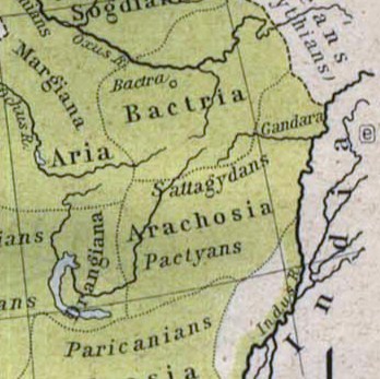
Español: Mapa histórico del Imperio Aqueménida.
English: Historic map of the Achaemenid Empire
Français : Carte historique de l'empire achéménide
Arachosia, Aria and Bactria were the ancient satraps of the Persian Achaemenid Empire that made up most of what is now Afghanistan and western Pakistan during 500 B.C. The main inhabitants of Arachosia were known as Pactyans, whose name possibly survives in today's Pakhtuns. |
||||
| Огноо | |||||
| Эх үүсвэр |
http://www.lib.utexas.edu/maps/historical/history_asia.html http://www.lib.utexas.edu/maps/historical/shepherd/persian_empire.jpg |
||||
| Зохиогч | William R. Shepherd (b. 1871 - d. 1934) | ||||
| Зөвшөөрөл (Энэ файлыг дахин ашиглах) |
|
||||
| Other versions | File:Map of the Achaemenid Empire.jpg (full) | ||||
Файлын түүх
Огноо/цаг дээр дарж тухайн үеийнх нь файлын байдлыг харна уу.
| Огноо/Цаг | Жижиг зураг | Хэмжээ | Хэрэглэгч | Тайлбар | |
|---|---|---|---|---|---|
| одоогийн | 13:48, 12 Гуравдугаар сар 2010 | | 348 × 347 (56 КБ) | Officer | {{Information |Description={{es|Mapa histórico del imperio Aqueménido.}} {{en|Historic map of the Achaemenid Empire}} {{fr|Carte historique de l'empire achéménide}} |Source=http://www.lib.utexas.edu/maps/historical/history_asia.html http://www.lib.ut |
| 20:47, 21 Нэгдүгээр сар 2010 |  | 324 × 357 (63 КБ) | Officer | {{Information |Description={{es|Mapa histórico del imperio Aqueménido.}} {{en|Historic map of the Achaemenid Empire}} {{fr|Carte historique de l'empire achéménide}} |Source=http://www.lib.utexas.edu/maps/historical/history_asia.html http://www.lib.ut |
Холбоос
Дараахь хуудсууд уг файлтай холбогдсон байна:
Файлын хэрэглээ (бүх төсөл)
Дараах бусад вики энэ файлыг ашигладаг:
- am.wikipedia.org дахь хэрэглээ
- ar.wikipedia.org дахь хэрэглээ
- azb.wikipedia.org дахь хэрэглээ
- az.wikipedia.org дахь хэрэглээ
- bg.wikipedia.org дахь хэрэглээ
- bn.wikipedia.org дахь хэрэглээ
- ca.wikipedia.org дахь хэрэглээ
- de.wikipedia.org дахь хэрэглээ
- en.wikipedia.org дахь хэрэглээ
- eo.wikipedia.org дахь хэрэглээ
- es.wikipedia.org дахь хэрэглээ
- he.wikipedia.org дахь хэрэглээ
- hi.wikipedia.org дахь хэрэглээ
- hr.wikipedia.org дахь хэрэглээ
- hy.wikipedia.org дахь хэрэглээ
- id.wikipedia.org дахь хэрэглээ
- it.wikipedia.org дахь хэрэглээ
- ja.wikipedia.org дахь хэрэглээ
- ka.wikipedia.org дахь хэрэглээ
- lt.wikipedia.org дахь хэрэглээ
- pt.wikipedia.org дахь хэрэглээ
- ro.wikipedia.org дахь хэрэглээ
- ru.wikipedia.org дахь хэрэглээ
- sh.wikipedia.org дахь хэрэглээ
- sk.wikipedia.org дахь хэрэглээ
- sr.wikipedia.org дахь хэрэглээ
- ta.wikipedia.org дахь хэрэглээ
- tg.wikipedia.org дахь хэрэглээ
- uk.wikipedia.org дахь хэрэглээ
Энэ файлын дэлхийн хэрэглээг харах.