Файл:Osaka Wards.png
Үзлэгийн хэмжээ : 600 × 600 пиксел Бусад зургын нягтрал: 240 × 240 пиксел | 480 × 480 пиксел | 972 × 972 пиксел.
Эх файл (972 × 972 пиксел, файлын хэмжээ: 237 КБ, MIME төрөл: image/png)
Товч агуулга

|
This locator map image could be re-created using vector graphics as an SVG file. This has several advantages; see Commons:Media for cleanup for more information. If an SVG form of this image is available, please upload it and afterwards replace this template with
{{vector version available|new image name}}.
It is recommended to name the SVG file “Osaka Wards.svg”—then the template Vector version available (or Vva) does not need the new image name parameter. |
| Тайлбар |
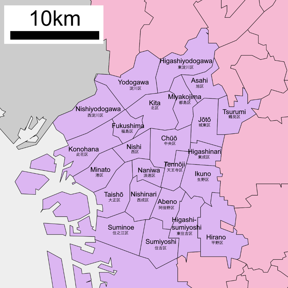
English: Map of wards of Osaka city |
| Огноо | |
| Эх үүсвэр | |
| Зохиогч |
|
Лиценз
ASDFGH at англи Википедиа, the copyright holder of this work, hereby publishes it under the following license:

|
Энэхүү баримт бичгийг GNU Free Documentation License, Хувилбарын нөхцлийн дагуу хуулах, түгээх болон/эсвэл өөрчлөх зөвшөөрөл олгосон. 1.2 эсвэл Чөлөөт програм хангамжийн сангаас нийтэлсэн дараагийн хувилбар; Инвариант хэсэггүй, нүүрэн талын текстгүй, арын хавтастай текстгүй. Лицензийн хуулбарыг GNU Free Documentation License гэсэн хэсэгт оруулсан болно. |
| Энэ файл нь Creative Commons Attribution-Share Alike 3.0 Unported лицензтэй байна. | ||
| Атрибут: ASDFGH at англи Википедиа | ||
| ||
| This licensing tag was added to this file as part of the GFDL licensing update. |
Original upload log
The original description page was here. All following user names refer to en.wikipedia.
- 2009-05-04 07:44 ASDFGH 700×700× (101767 bytes) {{Information |Description=Map of wards of Saitama city with numbers for accessibility |Source=*[[ja:ファイル:政令市区画図 27100.svg|政令市区画図 27100.svg]] |Date=2008-07-13 13:03 (UTC) |Author=*derivative work: [[User:ASDFGH|ASDFGH]] ([[
Файлын түүх
Огноо/цаг дээр дарж тухайн үеийнх нь файлын байдлыг харна уу.
| Огноо/Цаг | Жижиг зураг | Хэмжээ | Хэрэглэгч | Тайлбар | |
|---|---|---|---|---|---|
| одоогийн | 09:31, 22 Аравдугаар сар 2020 | | 972 × 972 (237 КБ) | AichiWikiFixer | Update |
| 12:51, 13 Есдүгээр сар 2010 |  | 700 × 700 (99 КБ) | Krisgrotius | {{Information |Description={{en|Map of wards of Osaka city<br/> en:Category:Osaka}} |Source=Transferred from [http://en.wikipedia.org en.wikipedia]<br/> (Original text : ''*[[:en::ja:ファイル:政令市区画図 27100.svg|政令市区画図 27100 |
Холбоос
Дараахь хуудсууд уг файлтай холбогдсон байна:
Файлын хэрэглээ (бүх төсөл)
Дараах бусад вики энэ файлыг ашигладаг:
- ast.wikipedia.org дахь хэрэглээ
- ba.wikipedia.org дахь хэрэглээ
- ca.wikipedia.org дахь хэрэглээ
- cs.wikipedia.org дахь хэрэглээ
- de.wikivoyage.org дахь хэрэглээ
- en.wikipedia.org дахь хэрэглээ
- es.wikipedia.org дахь хэрэглээ
- es.wikivoyage.org дахь хэрэглээ
- eu.wikipedia.org дахь хэрэглээ
- fi.wikipedia.org дахь хэрэглээ
- fr.wikipedia.org дахь хэрэглээ
- fy.wikipedia.org дахь хэрэглээ
- gl.wikipedia.org дахь хэрэглээ
- it.wikipedia.org дахь хэрэглээ
- ms.wikipedia.org дахь хэрэглээ
- nl.wikipedia.org дахь хэрэглээ
- pt.wikipedia.org дахь хэрэглээ
- ru.wikipedia.org дахь хэрэглээ
- sco.wikipedia.org дахь хэрэглээ
- th.wikipedia.org дахь хэрэглээ
- uk.wikipedia.org дахь хэрэглээ
- vep.wikipedia.org дахь хэрэглээ
- vi.wikipedia.org дахь хэрэглээ
- www.wikidata.org дахь хэрэглээ