Файл:Chagatai Khanate (1490).png

Үзлэгийн хэмжээ : 800 × 451 пиксел Бусад зургын нягтрал: 320 × 180 пиксел | 640 × 360 пиксел | 1,202 × 677 пиксел.
Эх файл (1,202 × 677 пиксел, файлын хэмжээ: 792 КБ, MIME төрөл: image/png)
.png)
Товч агуулга
| Тайлбар |
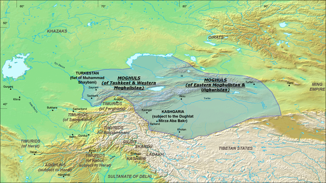
English: A map of the Moghul Chagatai Khanate in 1490 CE. Note: This map is compressed in vertical direction. Please, expand it about 1.3 times to see it undistorted.
ReferencesInformation for the borders of the Moghul khanate came mostly from these two sources:
|
| Огноо | 22 Долоодугаар сар 2008 (original upload date) |
| Эх үүсвэр | Transferred from en.wikipedia to Commons by Betta27. |
| Зохиогч | Ro4444 at англи Википедиа |
Лиценз
Ro4444 at the English Wikipedia, the copyright holder of this work, hereby publishes it under the following license:

|
Энэхүү баримт бичгийг GNU Free Documentation License, Хувилбарын нөхцлийн дагуу хуулах, түгээх болон/эсвэл өөрчлөх зөвшөөрөл олгосон. 1.2 эсвэл Чөлөөт програм хангамжийн сангаас нийтэлсэн дараагийн хувилбар; Инвариант хэсэггүй, нүүрэн талын текстгүй, арын хавтастай текстгүй. Лицензийн хуулбарыг GNU Free Documentation License гэсэн хэсэгт оруулсан болно. |
| Энэ файл нь Creative Commons Attribution-Share Alike 3.0 Unported лицензтэй байна. | ||
| Атрибут: Ro4444 at the English Wikipedia | ||
| ||
| This licensing tag was added to this file as part of the GFDL licensing update. |
Original upload log
The original description page was here. All following user names refer to en.wikipedia.
- 2008-07-22 06:20 Ro4444 1202×677× (811049 bytes) {{Information |Description={{en|1=A map of the Moghul (Chagatai) Khanate in 1490}} |Source=Own work by uploader |Author=ro4444 |Date=22 July 2008 |Permission= |other_versions= }} {{ImageUpload|full}} ==References== Information for the borders of the Mog
]]
Файлын түүх
Огноо/цаг дээр дарж тухайн үеийнх нь файлын байдлыг харна уу.
| Огноо/Цаг | Жижиг зураг | Хэмжээ | Хэрэглэгч | Тайлбар | |
|---|---|---|---|---|---|
| одоогийн | 07:16, 30 Аравдугаар сар 2010 | | 1,202 × 677 (792 КБ) | Betta27 | {{Information |Description={{en|''no original description''}} |Source=Transferred from [http://en.wikipedia.org en.wikipedia]; transfer was stated to be made by User:Betta27. |Date={{Date|2008|07|22}} (original upload date) |Author=. Original uploader |
Холбоос
Дараахь хуудсууд уг файлтай холбогдсон байна:
Файлын хэрэглээ (бүх төсөл)
Дараах бусад вики энэ файлыг ашигладаг:
- azb.wikipedia.org дахь хэрэглээ
- de.wikipedia.org дахь хэрэглээ
- en.wikipedia.org дахь хэрэглээ
- es.wikipedia.org дахь хэрэглээ
- fa.wikipedia.org дахь хэрэглээ
- fr.wikipedia.org дахь хэрэглээ
- it.wikipedia.org дахь хэрэглээ
- ja.wikipedia.org дахь хэрэглээ
- ko.wikipedia.org дахь хэрэглээ
- lt.wikipedia.org дахь хэрэглээ
- mni.wikipedia.org дахь хэрэглээ
- no.wikipedia.org дахь хэрэглээ
- ru.wikipedia.org дахь хэрэглээ
- sd.wikipedia.org дахь хэрэглээ
- sl.wikipedia.org дахь хэрэглээ
- ta.wikipedia.org дахь хэрэглээ
- tr.wikipedia.org дахь хэрэглээ
- uz.wikipedia.org дахь хэрэглээ
- vi.wikipedia.org дахь хэрэглээ
- zh.wikipedia.org дахь хэрэглээ
.png)